

Positions, co-ordinates
Navigating Earth's Geography
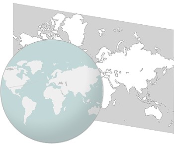
Understanding Earth's geography, represented as a spherical entity, poses a unique challenge when translating it onto flat surfaces like maps.
Over the centuries, cartographers have grappled with various projections to depict our three-dimensional world on two-dimensional charts.
The Mercator Projection, devised by Flemish geographer Gerardus Mercator in 1569, revolutionized maritime navigation.
 Unlike earlier artistic maps, Mercator's projection became an essential tool for sailors, enabling them to chart straight courses on maps.
Mechanics of the Mercator Projection
In this projection, longitude lines are straightened into parallel lines similar to latitude lines.
While this facilitates navigation, it introduces a trade-off – land masses are distorted, portrayed as a square that deviates from their true sizes.
Advantages and Drawbacks for Sailors
Sailors navigating specific regions, like the Greek islands, find the Mercator Projection advantageous. It allows the drawing of straight lines on charts, simplifying navigation between departure and destination points.
However, it introduces distortions, making Europe appear similar in size to Africa, despite being only a third of its actual size.

On longer voyages, such as the transatlantic journey from Ireland to New York, the Mercator projection may not be truly straight but rather curved.
The shortest path in such cases is the Great Circle, not the Rhumb line.
Mercator Projection's Enduring Significance
Despite its flaws, the Mercator Projection remains a crucial tool for practical navigation on marine charts.
Its ability to simplify course planning and straight-line navigation has cemented its place in the history of cartography.
Latitude
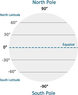 if you look at the picture of the earth (right), you will notice some black parallel lines drawn across the earth’s surface.
Latitude lines run horizontally on a map.
They measure the distance north or south of the equator, which is the line at 0 degrees latitude.
The equator is like the middle of the Earth.
As you move north, the latitude increases (e.g., 30° N is 30 degrees north of the equator).
As you move south, it decreases (e.g., 30° S is 30 degrees south of the equator).
Longitude
If you look at the next picture of the earth below, you will notice some vertical green lines drawn on the earth’s surface.
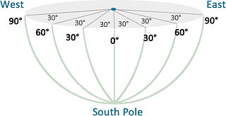 Longitude lines run vertically and measure the distance east or west of the Prime Meridian (0°), which passes through Greenwich, London.
As you move east, the longitude increases (e.g., 30° E is 30 degrees east of the Prime Meridian).
As you move west, it decreases (e.g., 30° W is 30 degrees west of the Prime Meridian).

Longitude is similar to latitude but it is measured vertically (east - west) from the meridian line that runs through Greenwich, England.
The longitude range runs from 0° - 180°.
The International Date Line
The meridian that is on the opposite side of the globe from Greenwich is known as the International Date Line and is 180° from Greenwich.
This is an imaginary line at 180° longitude.
Crossing it eastward or westward can change the calendar day.
It helps prevent confusion about time and date as we move around the Earth.
This line not only separates yesterday from tomorrow but also plays a significant role in the global timekeeping system.
As an airplane or ship crosses the International Date Line, it adjusts its date by subtracting or adding a day, depending on the direction.
This interaction between the International Date Line and the Prime Meridian ensures that our global time system remains synchronized.
Lat - Lon, Practical Example
Imagine you're on Mykonos, Greece, located at
LAT 37° degrees, 27 min, 0.0036 sec &
LON 25° degrees, 21 min, 0.0000 sec
As a side note for clarification, in decimal degrees (37.4500° N, 25.3500° E), these coordinates are commonly used in non-nautical contexts.
So, Mykonos is 37° degrees north of the equator and 25° degrees east of the Prime Meridian (Greenwich, London).
Remember, Latitude is like a ladder (you climb up or down), and Longitude is like a long line (you
move left or right).
Nautical mile
 A nautical mile is a unit of measurement used in navigation and marine contexts.
One nautical mile is defined as one minute of latitude.
This corresponds to one-sixtieth of a degree of latitude.
The length of one nautical mile is approximately 1.852 kilometers or 1.15078 statute miles.
Example
If you travel along the Earth's surface and cover a distance of 60 nautical miles, you would have traveled the equivalent of one degree of latitude.
Knot
The knot is a unit of speed used in navigation and maritime contexts.
One knot is equal to one nautical mile per hour
Therefore, a speed of 10 knots means a vessel is traveling at a speed of 10 nautical miles per hour.
The term "knot" is believed to have originated from the practice of using a knotted rope to measure the ship's speed.
Sailors would toss a buoyant object overboard connected to a rope with regularly spaced knots.
By measuring the time it took for the knots to pass through their hands, they could determine the ship's speed.
Knot Example
If a ship is traveling at a speed of 15 knots, it is covering a distance of 15 nautical miles in one hour.
In summary, a nautical mile is a unit of distance used in maritime navigation, and a knot is a unit of speed equivalent to one nautical mile per hour.
Together, these terms are crucial for measuring distances and speeds at sea.
The Earth's Magnetic Field
Navigation involves not only charting your course but also considering two critical factors: variation and deviation.
Let's break down these concepts in a simple and educational manner.
Variation
 The Magnetic Dance of Earth: Imagine Earth as a giant magnet with its own magnetic field.
This magnetic field doesn't align perfectly with the geographical North Pole.
Instead, it creates a difference between True North (the North Pole) and Magnetic North (where your compass points).
This difference is what we call "variation"
Deviation
Now, as you set sail, your vessel becomes part of this magnetic dance.
The metal components on board, like the engine, the rigging or navigation equipment, can influence the ship's magnetic field
 This influence causes the compass to deviate from the true magnetic course, introducing a factor known as "deviation"
Plotting the Right Course
In practical terms, when using a compass for navigation, you need to correct for both variation and deviation to ensure you're plotting the right course.
You adjust your compass reading by taking into account the local variation (which you find on charts or in a nautical almanac) and the specific deviation for your vessel.
Variation and Deviation: A Delicate Balance
Understanding and managing variation and deviation are crucial for accurate navigation.
- Variation is a constant for a specific location and can be accounted for in your navigation plan.
- Deviation, on the other hand, depends on your vessel and its unique magnetic properties, so it's essential to create a deviation card for your specific boat.
Educational Exercise: Mapping the Magnetic Dance
For an engaging learning experience, consider an activity where sailors map the magnetic dance of their vessel.
Use a compass to observe changes in direction as you move around the boat, noting how different areas might influence the reading.
This hands-on exercise helps demystify the concepts of variation and deviation, making navigation more accessible and enjoyable for all aboard.
Electronic vs. Manual Navigation
 In contemporary navigation, electronic charts dominate, accessible through GPS-enabled devices like tablets and phones.
While electronic systems streamline the process, a proficient sailor should also master manual, paper navigation for emergency situations.
Kavas Yachting's guide on manual coastal navigation covers essential techniques such as three-point fixes and Dead Reckoning, ensuring sailors remain well-versed in both realms.