


How to Navigate the Oceans and Waterways manually
As with anything electronic on a boat, your systems could go down. You will need to navigate manually.
When I learned to sail there was no such thing as an electronic chart, GPS was for posh people, and radar was an expensive bit of gear that told you of a contact ahead but not whether it was a supertanker or a lobster pot. Instead we navigated by hand, using a magnetic compass to get a ‘three point fix’ and when visibility was terrible, using something called Dead Reckoning (DR) and Estimated Position (EP).
Offshore? Everyone used a sextant and astral navigation.
Before you think I’m elderly, I’ll tell you I’m 43 in November - it is only in very recent times that people use AIS enabled radar, electronic charts and GPS.
The weakness of GPS
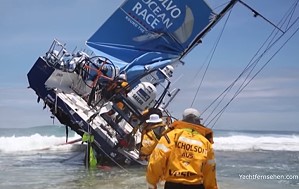
In December 2014 I had to be awake for 37 hours, looking after a loved one when they went into hospital. Shortly after we had been moved from Accident & Emergency to the next ward, I was looking at my Volvo Ocean Race app and discovered that Team Vestas had hit a reef of an atoll off Mauritius at 20 knots in the middle of the night.
The crisis as it unfolded gave me a grip on reality even as everything else in my world went to Hell in a handbasket. See the video of the accident here
The only fatality that night was the career of the navigator.
From being one of the best in the world, he can’t get a job as a navigator now.
The reason is that before he went to bed he made the assumption the boat would be in deep water for the whole time.
He didn’t zoom his chart in to the point he could see the atoll that would rip the bottom out of the boat.
Yes, even the best navigators in the world can make fatal errors like that!
A good yachtsman considers it a badge of honour to get home without calling for help
There are other reasons to learn basic navigation too.
- What would you do if you were on a passage and you had an electrical failure?
- What if your reserve, handheld GPS didn’t have batteries?
If something can go wrong, even on well maintained Kavas Greek charter boats, you will find it will go wrong. I’ve said this time and again in my articles here:
A good yachtsman considers it a badge of honour to get home without calling for help.
Being self-sufficient is part of the fun.
A final, and quite real possibility given the mad threats of US President Trump against North Korea, Venezuela and anyone else he finds that tweeting doesn’t bother, is that the US could go to war and shuts GPS down for everyone else. The Global Positioning System satellites are run by the US Military.
Back to my being an old fart again – when I was learning navigation, GPS had something called ‘selective availability’ where civilian GPS users had a stated accuracy of within 100 metres, 90% of the time. In a harbour that could mean you’re on the rocks thinking you’re in a deep water channel.
Whether setting out on an ocean crossing or merely island hopping on a Kavas yacht, you are down to your own devices:
Basic skills – the Fix, DR and EP
I’ve never had to do astral navigation and anyway for cruising the islands on a Greek yacht charter you will never be far from land.
You can follow the directions below even after nightfall using lighthouses and listed lights (such as cardinal marks) on the paper chart.
The three point fix
The “three point fix” is a basic skill you should know even if you started sailing after I did.
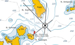 Look at the chart for key landmarks
that you should be able to see from the boat. The further apart they are from each other the better the fix will be. If you see a lighthouse dead ahead, a tower abeam and a church astern you will get a better fix than if there was a lighthouse 10 degrees from the tower abeam of you and a cardinal mark 15 degrees from the lighthouse.
Take your hand compass on deck
Then using the sighting with your eye, point the compass at each of the landmarks. Write down the angles you see on the hand compass, as quickly as possible as the vessel is moving.
Get down to the chart
Using a pencil (NEVER A PEN!!!) use a protractor or rose to draw a line from the landmarks out to sea. The first two will give you a rough point while the third will fix your position exactly. You might get a triangle called a ‘cocked hat’ – the bigger this is the worse the fix. If it is more than 10 metres in size, nip up on deck and do it again.
The Dead Reckoning (DR) process
Dead Reckoning (DR) is the least accurate of these disciplines but you need to know this in order to do the Estimated Position below.
- You do a simple speed / distance calculation from your fix.
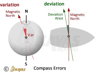
Distance = speed x time. - You then factor in your course from the magnetic compass, correcting it for variation and deviation.
Variation is the angle that the Magnetic North Pole is from the True (geographic) North Pole, and this moves every year.
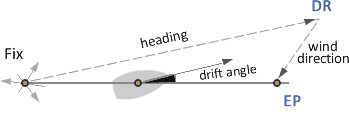
Deviation is the effects of the metals in the boat on the compass and will be individual to every yacht – it should be listed on your chart table. - You calculate your leeway by looking at the angle of your wake relative to the direction the vessel is pointed, using a hand compass.
Do a speed / distance calculation to work out how far away from your direction of travel you are (using a line on the chart). On a catamaran this could be 20 degrees or more when on a beat, while on a monohull you may only be 10 degrees out. 20 degrees off course in an hour could put you miles off course! - You work out your distance and plotted course and draw a small cross with your pencil on the chart along with the time.
Estimated Position (EP)
Estimated Position (EP) is where you can get a reasonably good estimate of where you are based the DR and local tidal currents. Beforehand you will have a three point fix on the chart, but you may be in heavy rain or fog and have no sight of land.
- You do your DR position.
- You look at the tidal currents book for the region you live in.
This will tell you what the current direction and speed is every hour after high tide in springs and neaps.
Do your speed / distance calculation again for the tidal currents, and mark the chart with a point surrounded by a triangle.
At night
As stated above you can do this at night, as the great thing about charts is that they mark prominent lights as well. There’s nothing stopping you (except Greek yacht charter insurance!) from doing quite accurate navigation at night using the tools that 43 year old farts like me used to have to do!
The more you sail the more accidents and incidents you will have. I’ve had sinkings, capsizes, near dismastings, engine, rudder and rigging failure in my time. The only time I’ve had to call for help was when I smashed my leg and had to get to hospital in a hurry – and even then had to teach the US Coastguard sailors how to tie a bowline to safely lower me in my stretcher onto their fast boat! Where the Greek coastguard will hear someone call them every so often to say “Help! I don’t know where I am!” only to quiz them some more for them to say “I’m off Corfu somewhere!”, we hope that you reading this article may not have to make a Charlie of yourself making just such a call when your electronics go down…
Fair winds!

See also ↠ Positions, co-ordinates