

Great Circle vs Rhumb Line: Why the Shortest Route Looks Curved on a Map
Rhumb Line vs Great Circle: Why Routes on Maps Look Curved
When looking at aircraft routes on world maps, you will often notice that planes do not appear to fly in straight lines between departure and destination. Instead, their routes seem to curve across the globe.
The same is true for ocean liners and racing yachts. When plotted on many maps, their routes often appear curved rather than straight.
This can be confusing at first. Why would ships and aircraft avoid what looks like the shortest path?
The answer lies in the difference between a Rhumb Line and a Great Circle route.
What Is a Rhumb Line?
A Rhumb Line (also called a loxodrome) is a route that follows a constant compass direction.
On a Mercator map projection, a rhumb line appears as a straight line between two points. Because the bearing never changes, it was historically easier for navigators to follow using traditional navigation instruments.
However, while it appears straight on the map, it is usually not the shortest distance over the curved surface of the Earth.
Rhumb Line Example
On a Mercator chart, the Rhumb Line between two locations appears perfectly straight.
This visual simplicity made rhumb lines extremely useful for navigation for centuries.

What Is a Great Circle Route?
A Great Circle is the shortest distance between two points on the surface of a sphere such as the Earth.
Unlike a Rhumb Line, a Great Circle route does not maintain a constant compass heading.
Instead, the course gradually changes as the route follows the natural curvature of the planet.
Because of this, Great Circle routes often appear as curved lines on flat maps.
Great Circle Example
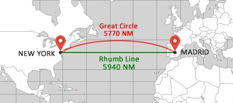
For example, when comparing routes between Madrid and New York:
- The Rhumb Line (green line) measures about 5940 nautical miles.
- The Great Circle route (red curve) measures about 5770 nautical miles.
This difference of around 170 nautical miles can represent many hours of travel for ships or aircraft.
Understanding Great Circle Navigation with a Simple Example
An easy way to visualize a Great Circle route is to imagine placing a piece of string on a globe.
If you stretch the string between two points across the globe, the string naturally follows the shortest possible path. This path represents the Great Circle route.
If you instead forced the string to remain parallel to the equator, it would represent a Rhumb Line, which is usually longer.
The Mercator Projection: Why Maps Can Be Misleading
Most nautical charts and world maps use the Mercator Projection, developed in the 16th century by the Dutch geographer Gerardus Mercator.
This projection flattens the curved surface of the Earth into a rectangular map while preserving accurate compass bearings.
While this makes navigation easier, it also creates distortions.
For example, although New York lies roughly on the same latitude as Madrid, the shortest route between them is not the straight line shown on a flat map.
Instead, the shortest path is a northward curving Great Circle route, which typically arcs toward Greenland before turning south again toward North America.
Key Differences Between Rhumb Line and Great Circle Routes
Both rhumb lines and great circle routes are used in navigation, but they behave very differently on the Earth's surface and on nautical charts. The table below summarizes the main differences between the two navigation methods.
| Feature | Great Circle (Orthodromic) | Rhumb Line (Loxodromic) |
|---|---|---|
| Definition | The shortest path between two points on the Earth's surface. | A route that follows a constant compass bearing. |
| Distance | Shortest possible distance. | Usually longer. |
| Navigation | Course changes continuously. | Constant heading. |
| On Mercator Map | Curved line. | Straight line. |
| Best Use | Long ocean crossings and aviation. | Coastal sailing and short passages. |
Now that we understand the difference between rhumb lines and great circle routes, we can see how this principle is used in real-world navigation — especially in aviation.
Why Airplanes Follow Great Circle Routes
If you look at flight paths on a world map, many airline routes appear to curve dramatically. Flights between Europe and North America, for example, often arc far north toward Greenland or Iceland instead of following a straight east-west line.
This happens because aircraft usually follow Great Circle routse, which represent the shortest distance between two points on the Earth’s surface.
Because the Earth is spherical, the shortest route across the globe is rarely a straight line on a flat map.
Instead, the route curves when shown on a Mercator projection.
Why This Matters for Aviation
For aircraft, distance directly affects fuel consumption. Modern airliners burn thousands of kilograms of fuel per hour, so even small reductions in distance can significantly reduce operating costs.
By following a Great Circle, airlines can reduce flight distance, fuel usage, and overall flight time.
Why Aircraft Do Not Always Follow a Perfect Great Circle
Although Great Circle routes represent the shortest distance, aircraft do not always follow them exactly.
Airline route planners must also consider factors such as:
- Jet stream winds
- Air traffic control corridors
- Weather systems
- Restricted airspace
- Emergency diversion airports
Because of these constraints, the actual flight path is often a modified version of the theoretical Great Circle route.
Great Circle Navigation at Sea
The same principle is used by ships crossing the Atlantic or Pacific oceans. Long-distance voyages are often planned along Great Circle routes to minimize distance and fuel consumption.
The Titanic and the Risks of the Shortest Route
While a Great Circle route represents the shortest distance between two points on Earth, it is not always the safest route for ships.
On transatlantic crossings between Europe and North America, the shortest route naturally curves northward across the Atlantic. Unfortunately, these higher latitudes are also where ships are more likely to encounter icebergs and severe weather.
One of the reasons the RMS Titanic encountered icebergs was that she was following a route close to the Great Circle.
The captain was attempting to make a fast crossing in pursuit of the famous Blue Riband — an unofficial accolade awarded to the passenger liner crossing the Atlantic with the record highest average speed.
Taking the shortest route placed the ship farther north in the Atlantic, where iceberg danger was significantly greater.
For this reason, many captains do not follow a pure Great Circle route. Instead, they plan a modified route known as a Composite Great Circle.
This method begins with the theoretical Great Circle, but limits how far north the ship will travel. The vessel then follows a safer track before eventually returning toward the destination.
Although this route is slightly longer than the shortest possible path, it keeps the vessel farther from the worst weather, heavy seas, and iceberg zones.
Course Adjustments on a Great Circle Route
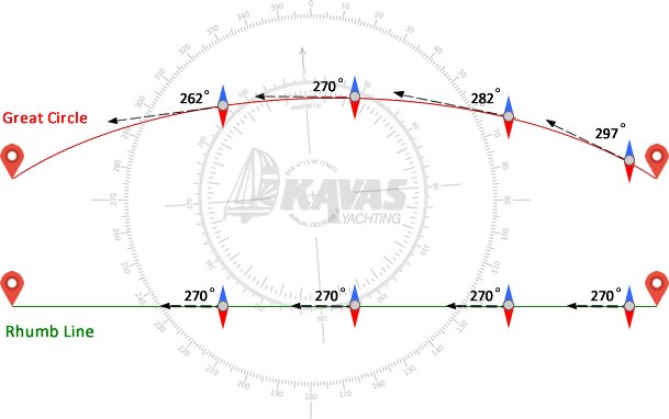
One important difference between a Great Circle route and a Rhumb Line is how the vessel must be steered.
On a Rhumb Line, the compass heading remains constant throughout the voyage. Once the course is set, the vessel simply follows the same direction until reaching its destination.
On a Great Circle route, however, the direction gradually changes as the vessel follows the curved surface of the Earth. In theory, the course would need to be adjusted continuously.
For aircraft traveling at around 500 mph, these course adjustments happen constantly during flight. But for sailing yachts, which may cover only 200–250 nautical miles per day, navigators typically adjust the course periodically rather than continuously.
This means that many long-distance voyages follow a practical compromise: a route that approximates the Great Circle while remaining manageable for the crew to steer.
Conclusion
In navigation, the shortest route is not always the simplest one.
A Great Circle route provides the shortest distance between two points on the Earth, which is why it is widely used in aviation and long ocean crossings.
A Rhumb Line, on the other hand, offers simplicity by maintaining a constant compass direction, making it practical for coastal sailing and shorter passages.
Good navigators balance distance, safety, weather conditions and ease of steering when choosing the best route across the sea.
 Vaggelis Kavas
Founder of Kavas Yachting & Marine Technical Specialist
Vaggelis founded Kavas Yachting in 1985, building on his extensive technical background in the Navy's submarine service. With over 30 years of hands-on experience and thousands of miles sailed, he personally oversees the technical integrity and safety standards of the Kavas fleet. His mission is to bridge professional maritime discipline with the authentic joy of Greek island hopping.